Walking and hiking in Slovenia
Slovenia is truly an alpine country with nearly 30 peaks over 2,000m, many of them in the Julian Alps, or in the Kamnik and Savinja Alps. These two areas are great places in Slovenia to go mountaineering, walking, hiking and mountain biking.
Walking and hiking in the Julian Alps
The main bulk of the Julian Alps lie within the borders of Slovenia, in the northwest corner of the country, and it includes Slovenia’s highest peak – Triglav at 2,864m high. The limestone scenery here is outstanding with steep rock faces plunging into forests and flower meadows, whilst waterfalls and rivers cascade from the cliffs only to mysteriously disappear into the bedrock and re-emerge elsewhere. Beautiful open pastures and forests nestle beneath these fantastic mountains.
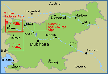
Map of the main walking areas in Slovenia

The Triglav National Park covers most of the Julian Alps range, and it is an area where the walker and not the motorist who reigns supreme. The footpaths and trails are well maintained and sign posted, plus there are many mountain huts scattered throughout the park providing refreshments and accommodation.
Triglav is the most visited of Slovenia’s highest mountains; there is even a saying that to become a true Slovene, you must summit Triglav at least once in your life. However Triglav is no easy mountain with the summit pyramid being steep and exposed. It requires the mountaineer to be able to move confidently along steel ropes and iron pitons, using via ferrate equipment, without being afraid of heights. You need to be reasonably fit to ascend Triglav safely, as even the shortest approach tackles more than 1,700m of ascent. The Triglav hiking guidebook describes 8 classic approaches to the top of Triglav from all sides across a wide range of difficulties. Buy this guidebook from our shop.
The Julian Alps can still be enjoyed by walkers and hikers without ascending Triglav, with hundreds of walking routes to suit all abilities. In the Bohinj Valley and around Lake Bled there are numerous easy paths with little height gain, whilst the harder routes up to the various mountain peaks will require some alpine experience. Walking the Julian Alps of Slovenia guidebook describes 58 short treks and mountain walks that can be bought from our shop.
A series of 1:25,000 walking maps are also available for Bohinj, Triglav and Bovec that are available to buy from our shop. The Triglav Walking Map covers the town of Kranjska Gora, the Martuljek waterfalls, Bohinj Lake plus Triglav Mountain, as wellas detailing all the contact information for the various mountain huts in the area.
Walking in the Kamnik and Savinja Alps
The Kamnik and Savinja Alps are located in the north of Slovenia, on the border with Austria, and are quieter than its neighbouring Julian Alps. The scenery is a typically alpine with about three quarters of the surface covered with forest, and many of the higher peaks are bleak and rocky. The highest mountain of the Kamnik and Savinja Alps is called Grintovec at a height of 2,558m, and there are many other mountains over 2,000m high.
The footpaths and trails in the Kamnik and Savinja Alps are well maintained and sign posted, providing many excellent walks to suit all abilities. There is also a good network of mountain huts that provide refreshments and accommodation.
The Kamnik and Savinja Alps walking map details all the walking paths and trails at a scale of 1:25,000. It also includes all the contact information for the various mountain huts in the Kamnik and Savinja Alps
Walking and Mountain Biking in the Soca Valley
The Soca Valley lies between the Julian Alps and the Adriatic Sea in a picturesque and fascinating valley that is great for walking, hiking and mountain biking. This valley was the scene of some intense fighting during the First World War, and the history of these battles is still seen today. The Pot Miru long distance walk (Walk of Peace) is 100km long and it links the tranquil Soca Valley with its meadows and mountains, with the most important remains museums, and memorials from the First World War. The Pot Miru walk starts at Log pod Mangartom at the entrance to the mine shaft named Štoln, and ends at the outdoor museum Mengore near Most na Soči. Sections of this long distance walk are detailed in the Walking in the Julian Alps of Slovenia Guidebook that is available to buy from our shop.
The Soca Valley is also a great place for mountain biking with many excellent paths and trails. Again relics from the First World War have left a vast network of high-altitude supply routes (called mulatieras) that are ideal for reaching and crossing mountains on a bike. The Mountain Biking in Slovenia Guidebook covers many routes in the Soca Valley and throughout Slovenia, and is available to buy from our shop.