Walking and hiking in Sardinia
Sardinia is a mountainous country and as such offers a great range of walking experiences. These range from gentle rolling hills and valley walks, to mountain ranges in the centre of the island up to 1,800m high, and a dramatic coastline with many steep limestone cliffs. Much of this country is unspoilt and remote that means for walkers Sardinia can be a great adventure. Many trails run along ancient shepherds’ or charcoal burners’ paths, the routes of which are only occasionally waymarked with cairns. However in places new hiking paths are being constructed plus old ones are being cleared and reopened. Now many trails and paths have been marked with coloured waymarkers along with wooden signposts.
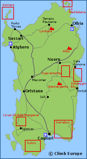
The map shows the main mountain ranges, National Parks and Regional Parks in Sardinia that are of interest from walkers and hikers.
The highest mountain in Sardinia is found in the Gennargentu Massif (Monti Del Gennargentu), and is called Punta La Marmora at 1,834m high. The Gennargentu Massif is a rugged mountain range and is a natural unspoilt beauty in the centre of the island. It is also the largest National Park in Sardinia that extends eastwards including the Supramonte Massif and the Gulf of Orosei (Parco Nazionale Gennargentu e Golfo di Orosei). Supramonte is Sardinia’s second highest massif, and is popular with both walkers and rock climbers, with Monte Corrasi (1,463m) being its highest point.
Sardinia’s two other National Parks are both in the north of the island, which are the Maddalena Islands (Isola La Maddalena) and Asinara Island (Isola Asinara). Coast Map 6 covers the Asinara Island that shows all the walking and hiking paths in these National Parks and is available to buy from our shop. Also in the north of Sardinia, are two other significant mountain ranges. Furthest north is Monte Limbara, with the highest peak being Punta Balistreri at 1,362m high. Monte Albo is a limestone massif whose highest point is 1,127m.
Map of Sardinia’s main mountain ranges and National Parks

The Selvaggio Blu follows the wild coastline of the Gulf of Orosei, from Santa Maria Navarrese to Cala Gonone and is Sardinia’s hardest trek – with some justification. Parts of this trek are extremely technical and demanding involving some short stretches of rock climbing and abseiling. The route is physical and there is always the issue of the constant lack of water found along the route. Find out more…
Located to the northeast of the capital Cagliari are the Sarrabus Mountains, which also includes the Sette Fratelli-Monte Genas Regional Park. The Sarrabus Mountains are mainly covered with oak forests and are sparsely populated with the nearest town being Burcei. The highest point of the Sarrabus Mountains is called Punta Serpeddi at 1,069m high. Sette Fratelli is a limestone ridge with bizarre spires that provides great views over Cagliari and the coast. To the west of Cagliari are the limestone Sulcis Mountains that are again covered in trees, though there are two summits above 1,000m. These are Punta Rocca Steria (1,009m) and Monte is Carràvius (1,116m).
The walking paths and trails for Sarrabus and the Sette Fratelli-Monte Genas Regional Park are shown on Coastal Map 1 and Coastal Map 12. The peak of Punta Serpeddi is shown on Coastal Map 1.
To the northwest of Cagliari is the Monte Linas-Oridda-Marganai Regional Park. These are a series of rugged mountains and forests with canyons, caves and waterfalls. The highest point is Monte Linas at 1,236m high. Coastal Map 3 shows the walking paths in the Monte Linas-Oridda-Marganai Regional Park.