Walking around Dinara Mountain
The Dinaric Alps cover many countries in central Europe, and in central Croatia they form a natural border between Croatia and Bosnia and Herzegovina. It is here where the highest point in Croatia is found, which is called Dinara Mountain and is 1,831m high.
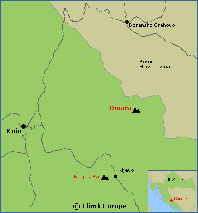
The best way to reach Dinara is from the town of Knin. Take the road from Knin towards Kovačići and then onto the hamlet of Guge. Here the asphalt ends and the continuing road is in a very bad state that is only suitable for 4-wheeled vehicles. Carry on along this road towards the “Dry Plain”, a large plateau that is at an altitude of around 900m. On entering the Dry Plain, the road broadens at a place called “Mark’s Tomb”, where it is possible to park the car. It is possible to walk from Guge to this point by following the marked path that cuts through the road, but it a long and tedious route. Continue walking from the Dry Plain up forest tracks to the Brezovac Mountain Hut to stay overnight. From this hut it takes around 3 hours to reach the top of Dinara.
The best time to walk and hike around Dinara in the Dinaric Alps is from May to October. Outside this period the weather is harsh with lots of snow, frequent fog and often very low temperatures. The best walking map for Dinara is called “Dinara Mountain Map” that is available to buy from our shop.
Map showing the location of Dinara Mountain near the town of Knin

Another popular peak that is close by is called Kozjak Bat, which is 1,206m high. The easiest way to reach Kozjak Bat is from the village of Kijevo, and is also covered on the Dinara Mountain Map.
The Walks and Treks in Croatia guidebook covers 27 varied walks across Croatia including the Dinaric Mountains, and is available to buy from our shop.

Brezovac Mountain Hut is a popular place to stay when ascending Dinara Mountain