Walking in Sjeverni Velebit National Park
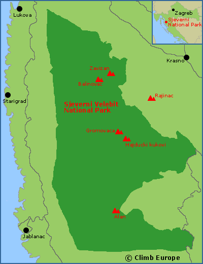
The Sjeverni Velebit National Park (Northern Velebit National Park) is a vast National Park with many peaks over 1,600m high. These include Veliki Rajinac (1,699m), Hajdučki kukovi (1,650m), Gromovača (1,676m), Veliki Zavižan (1,616m), and Balinovac (1,602m). The National Park is located between the Adriatic coastal towns of Lukova and Jablanac in the west and the town of Krasno in the east.
There are various marked walking and mountaineering trails in the National Park to suit walkers of all abilities that are well marked with good clear sign posts. These range from easy half day walks to longer multi-day hikes using a number of mountain huts in the National Park. The Sjeverni Velebit National Park Map published by SMAND (map number 16a) shows many of these marked trails at a scale of 1:30,000, and is available to buy from our shop.
The limestone rock in the Velebit Mountains also contains lots of caves and sinkholes. The deepest sinkhole is found near the peak of Hajdučki kukovi, which is called Lukina jama and is over 1,000m deep.
The Walks and Treks in Croatia guidebook covers 27 varied walks across Croatia including the Sjeverni Velebit National Park, and is available to buy from our shop.
Map of Sjeverni Velebit National Park between the towns of Krasno, Lukova and Jablanac

A popular long distance path is called the Premuzic Trail (Premužiceva staza) that runs through the heart of northern Velebit and is 57km long. This stone path was created in the 1930s and starts at the peak of Zavižan and finishes at Baske Ostarije. The first 16km of this trail is in the Sjeverni Velebit National Park and is considered the most beautiful with breath taking views over the Adriatic Sea. This 16km section starts at Zavižan, passes over the peaks of Gromovača and Hajdučki before finishing at Alan, and takes around 8 to 9 hours to walk. Two maps published by SMAND cover the complete Premuzic Trail, with map number 16a covering the northern half from Zavižan to Alan. Map number 17 covers the southern half from Alan to Baške Ostarije. Buy both of these maps from our shop.
The Premuzic Trail also forms part of Croatia’s longest hiking trail that is called Velebitski planinarski put (Velebit Hiking Trail) and is around 100km long that finishes at Starigrad Paklenica in the south.
The Velebit Nature Park (Park Prirode Velebit) covers the whole of the Velebit Mountains from Senji in the north to the outskirts of Zadar in the south. Within this Nature Park are 2 National Parks, these being Sjeverni Velebit National Park and Paklenica National Park. The Velebit Mountains were part of an important trading route from the interior of Croatia to the coast. These ancient trading routes that crisscrossed the Velebit Mountains are now excellent hiking paths and trails. The northern area of the Velebit Nature Park from Senji to the edge of the Sjeverni Velebit National Park is covered by SMAND map number 16, called Sjeverni Velebit, and includes the Senjsko Bilo ridge. Buy this Sjeverni Velebit map from our shop.