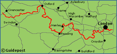
Walking the Thames National Trail long distance path
The Thames National Trail long distance path is 184 miles (294 Km) long.
The Thames National Trail follows the Thames from its source in the Cotswolds near Cirencester to the Thames Barrier just outside of London where the River Thames meets the sea. The trail offers a great variety of scenery from the initial meandering source through several rural counties to the heart of England’s capital London.
The Thames National Trail passes through the cities of Oxford and Reading as well as several historic market towns such as Abingdon, Lechlade and Henley. All along this trail are numerous riverside pubs, country houses, churches and an amazing variety of bridges dating from the 14th century to the present day.
Map of the Thames National Trail long distance path

What maps and guidebooks are available for the Thames National Trail long distance path?
Buy walking maps and guidebooks for the Thames National Trail Path from our shop.
Buy walking maps and guidebooks for the Thames National Trail Path from our shop.


